St. Louis Area District Welcome to MoDOT Banner Contact, Survey, Jobs, News, Site Map
Our mission is to provide a world-class transportation experience that delights our customers and promotes a prosperous Missouri.
Route 141 Improvement Project (Ladue to Olive)

Topics:


Facts About the Project

The Rte. 141 improvement project is a future project to improve safety and traffic flow, prevent flooding and reduce congestion along Route 141 between Olive Boulevard (Route 340) and Ladue Road (Route AB).

What is the Problem With Route 141 Between Ladue and Olive?

There are three major problems with Route 141 between Olive and Ladue: congestion, safety and flooding. Route 141 was built in the 1930s and cannot handle current traffic. More than 23,000 cars a day use this two-lane stretch of roadway, and several intersections are highly congested. Traffic levels over the next 20 years are expected to increase by up to 35% in some locations. Accident rates have risen over the last five years to almost double the statewide average, and the road typically floods several times a year.

What Is the Proposed Solution?

The proposed improvements include relocating Route 141 to the east of the existing alignment. The preferred alignment is a six-lane road east of existing Route 141 and will also add two through lanes in each direction along Route 141 between Ladue Road and I-64/Rte. 40. A single point urban interchange is proposed at Olive Boulevard, and a diamond interchange is proposed at Ladue Road. A connection between existing Route 141 and Old Woods Mill Road is also proposed. This final piece of the Route 141 corridor project will provide a continuous multi-lane arterial from Olive Boulevard south to Interstate 55 through St. Louis and Jefferson counties.

MoDOT is also proposing to move the Ladue/Rte. 141 interchange further to the east and construct it in a single point design. This design is similar to the Manchester and Rte. 141 interchange, except that Rte. 141 will go under Ladue Rd. A single point interchange is controlled by one set of traffic signals located at a single point at the center of the interchange. The signals direct thru-traffic, as well as all traffic that must turn left to enter or leave the highway.

A two-lane roundabout is also proposed just to the west of the proposed Rte. 141 and Ladue Rd. interchange, connecting existing 141 with Woods Mill to the south. The roundabout will serve Parkway Central High School and subdivisions west of Rte. 141. By building a roundabout at this location, MoDOT was able to safely move the intersection further east of the previously proposed intersection location. The roundabout will be located east of Creve Coeur Creek. In a previous plan an intersection was proposed west of the creek.

Why is this the best solution?

After comparing issues such as overall cost, environmental impacts and residential/business impacts, this option best addresses the problems and needs in the corridor while minimizing the negative impacts. This alignment will minimize the overall impacts to residents, businesses, and wetlands while reducing congestion and improving safety. Other options for the Route 141 corridor include reconstructing the roadway along the existing alignment and moving the alignment further to the east. However, these two options would cost an additional $17-25 million to build. Besides cost, the alignment that moves Route 141 further to the east is a less desirable option. It is a longer, less direct route than the preferred alignment with several curves that makes it less than desirable. Final selection of an alternative will be made when all public comments can be evaluated.

Where Does the Project Stand Today?

In December 2002 the Federal Highway Administration approved the Environmental Assessment document for the Route 141 widening project between I-64/Rte. 40 and Olive Boulevard. In January 2002 the 
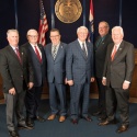
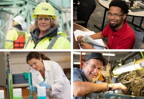
Missouri Highways and Transportation Commission approved the preliminary design and location of Rte. 141 from south of Ladue Rd. to north of Olive Blvd. This project is not funded.

Estimated Project Costs:
  • Estimated construction costs to improve Route 141 between Olive and Ladue: $60 million
  • Estimated cost to purchase right of way for the project: $35 million

Back to Topics


Project Timeline

This project is not funded. The Route 141 project is currently in MoDOT's long-range plan for 2011 to 2020.  The earliest construction could begin is 2011 if funds become available.


Back to Topics


Route 141 Project Map


Back to Topics


Route 141 And Ladue Rd. Interchange Map

* NOTE * The red lines on the map indicate the location of the interchange under the previous design plan (presented at the July 10 public meeting).

Following public meetings in June 2000 and July 2001, and a town hall meeting in August 2001, the Missouri Department of Transportation (MoDOT) has unveiled revised design plans for a new interchange at Route 141 and Ladue Road. The new design plans come as a result of public input gathered at the previous public meetings.

MoDOT is proposing to move the Ladue/Rte. 141 interchange further to the east and construct it in a single point design. This design is similar to the Manchester and Rte. 141 interchange, except that Rte. 141 will go under Ladue Rd. A single point interchange is controlled by one set of traffic signals located at a single point at the center of the interchange. The signals direct thru-traffic, as well as all traffic that must turn left to enter or leave the highway.

MoDOT is also proposing to construct a two-lane roundabout just to the west of the proposed Rte. 141 and Ladue Rd. interchange, connecting existing 141 with Woods Mill to the south. The roundabout will serve Parkway Central High School and subdivisions west of Rte. 141. By building a roundabout at this location, MoDOT was able to safely move the intersection further east of the previously proposed intersection location. The roundabout will be located east of Creve Coeur Creek. In the previous plan an intersection was proposed west of the creek.

A roundabout is a one-way circular intersection where vehicles move in a counter-clockwise direction, and all entering traffic yields to traffic already in the roundabout. Roundabouts reduce driver delay by allowing motorists to yield rather than stop. Accidents also decrease because conflict points (spots where vehicles could collide) are minimized, and speed is lower compared to signalized intersections.

This proposal will be submitted to all reviewing federal agencies by the end of 2001. MoDOT expects a reply from these agencies by April 2002.

A map of the revised design plans for the Rte. 141 and Ladue Rd. interchange and roundabout west of the interchange can be viewed at the Creve Coeur, Town and Country, and Chesterfield city halls.

This project includes relocating and widening Rte. 141 to the east of existing Rte. 141 with interchanges planned at Olive Blvd. and Ladue Rd. Construction is currently scheduled to begin after 2004 when funding becomes available. The project is estimated at costing approximately $75 million. There is currently no funding available for this project.


Back to Topics


Route 141 Summary of Impacts


Back to Topics


Send Us Your Comments

For comments or questions about the project, please e-mail MoDOT Project Manager Tom Montes de Oca or MoDOT Area Engineer Karen Yeomans.


Back to Topics


The documents are provided in Acrobat Reader format. Free Acrobat Reader download PDF Icon

Updated Jan 2, 2007


TRAFFIC CONTACT CONTACT SURVEY SURVEY CAREERS CAREERS NEWS NEWS SITEMAP SITEMAP TRAFFIC Kansas City Area Southwest District North Central District Central District Springfield Area Northeast District St. Louis Area South Central District Southeast District Northwest District